

Fast delivery within 72 Hours
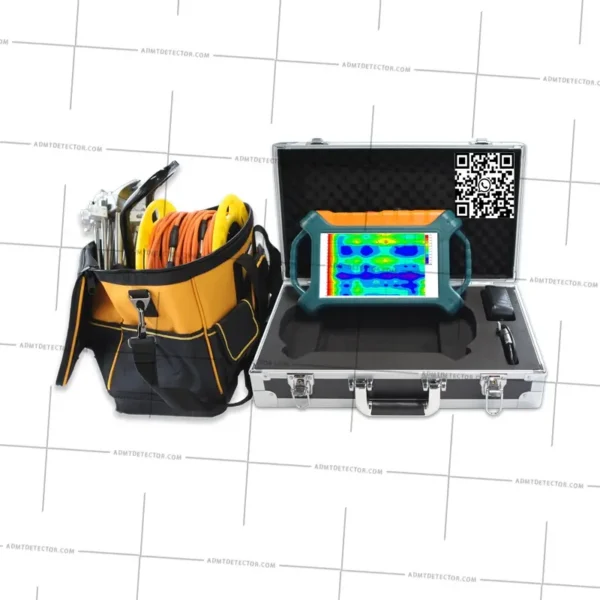
ADMT-200AX 500AX Professional Electromagnetic GroundWater Finder Detector
€ 5,500.00


Fast delivery within 72 Hours
ADMT-200AX 500AX Professional Electromagnetic GroundWater Finder Detector
€ 5,300.00
ADMT-200AX 500AX Professional Electromagnetic GroundWater Finder Detecto/ ADMT-200AX 500AX Professional Electromagnetic GroundWater Finder Detector


- Model:ADMT-200AX ADMT-500AX
- Adjustable detection depth:MAX 200M/500M
- mainframe probe integrated, MN ,TT
- Professional Electromagnetic Groundwater Detector
| Model Number | ADMT-200AX, ADMT-500AX |
|---|---|
| Place of Origin | China |
| Measurement Mode | MN, TT |
| Brand Name | ADMT |
| 11 promotional models | All models |
Details About ADMT-200AX 500AX Professional Electromagnetic GroundWater Finder Detector
The ADMT-200AX and 500AX are revolutionary, mobile groundwater detection instruments, representing a significant upgrade in water prospecting technology. Designed for professionals, these devices offer efficient and accurate groundwater resource detection at depths of up to 200m (ADMT-200AX) and 500m (ADMT-500AX)
- Advanced Electromagnetic Technology: Utilizing cutting-edge geophysical exploration technology for superior accuracy in water detection.
- Mobile & Smart: Control the device directly from your smartphone or tablet for real-time data analysis and unparalleled portability.
- Automatic 2D/3D Imaging: Generate detailed 2D and 3D geological images instantly in the field, providing a clear visualization of groundwater location and depth.
- Increased Resolution & Precise Depth Selection: Experience higher resolution data and more accurate depth mapping compared to traditional methods, leading to more successful water well drilling.
- Efficient Water Prospecting: Save time and resources with a fast, reliable, and easy-to-use water finding instrument.
- Professional Water Prospector: The upgraded model offers unparalleled data and more accurate readings.
Operating Principle: Listening to the Earth’s Subsurface Signals
The ADMT-200AX and ADMT-500AX groundwater detectors operate on the principle of the “Natural Electric Field Frequency Selection Method,” a sophisticated geophysical technique also known as the Audio-Magnetotelluric (ADMT) method. These advanced instruments cleverly leverage the Earth’s naturally occurring electromagnetic fields to pinpoint underground water sources.
| Model | ADMT-200AX | ADMT-500AX |
| Maximum depth(m) | ≤200 | ≤500 |
| Channel input | 1 Channel MN input | |
| Channel option | 1 | |
| Optional depth(m) | 100-200 | 100-500 |
| Deep stratification | 10-100 | |
| Connection type | Serial port, Wifi, Bluetooth 4.0, USB(optional 4G communication) | |
| Display | 7inch IPS wide-angle 178 ° visual touch screen | |
| Operating system | Android 13 | |
| CPU | RK3568 | |
| GPU | Mali G52 | |
| Main function | Depth optional, real-time 2D/3D mapping, battery removable | |
| Measure model | MN/TT(Optional) | |
| Frequency range(HZ) | 1-8K | |
| Frequency-selective filtering | Preset frequency selection and intelligent frequency selection, analog + data filtering 1-16 overlay options | |
| Resolution ratio | 0.1mV±2% | |
| Sampling time(s) | 100-360 | |
| Battery power consumption | 700mA/H | |
| Main engine weight | 1.6kg | |
Key Features & Advantages:
Precise Detection up to 200/500 Meters:
Capable of detecting depths up to 500 meters with adjustable interval settings such as 5m, 10m, and 20m to meet various accuracy requirements.Smartphone Control & Mapping:
User-friendly dedicated app with simple operation.
Real-time data curves displayed during measurement.
Instantly generates 2D cross-sections, 3D models, and slice maps post-measurement, providing intuitive visualization of subsurface structures and water anomalies.
Dual Measurement Modes for Various Terrains:
- MN Electrode Method: A traditional two-electrode measurement method that inserts alloy electrodes into the ground, suitable for most terrains.TT Electromagnetic Probe Method: A portable probe measurement method that requires no electrodes, ideal for hard surfaces such as concrete, asphalt, or exposed bedrock, greatly expanding the instrument’s application range.
AI-Based Smart Analysis:
Built-in AI functions analyze results and offer water detection suggestions, reducing the reliance on professional expertise.Portable & Easy to Use:
Compact main unit combined with smartphone operation allows a single person to complete the entire field survey, significantly improving work efficiency.Cloud Data Storage & Online Consulting (Select Models/Services):
Measurement data can be stored on the phone for easy viewing, export, and sharing. Advanced services may include cloud uploads and expert interpretation consulting.Online/Offline Measurement Support:
Multiple modes accommodate both connected and disconnected environments.Highly Efficient & Stable:
Powered by a high-performance lithium battery with low power consumption and long endurance. Optimized circuitry ensures strong anti-interference capability and stable, reliable data.
Main Application Fields:
Locating Drinking Water Sources:
Quickly identify well locations for domestic use in drought-prone, mountainous, or remote villages.Irrigation for Farmlands and Orchards:
Solve agricultural water supply issues and support farming productivity.Engineering Construction Surveys:
Map underground water before major construction (railways, highways, bridges, tunnels) to avoid risks.Geological Surveying:
Conduct hydrological surveys to understand groundwater structures.Mineral Exploration:
Assist in locating mineral resources associated with groundwater.Geothermal Exploration:
Preliminary investigation of geothermal anomaly zones.
Specification
 Overview
Customer Reviews
Shipping & Delivery
-
Courier delivery
Our courier will deliver to the specified address
2-3 Days
From $20
-
DHL Courier delivery
DHL courier will deliver to the specified address
2-3 Days
From $40
-
Warranty 1 year
-
Free 30-Day returns

Black Friday Blowout!
Specification
Overview
Processor
Display
RAM
Storage
Video Card
Connectivity
Features
Battery
General
Description
Fast delivery within 72 Hours
ADMT-200AX 500AX Professional Electromagnetic GroundWater Finder Detector
€ 5,300.00
ADMT-200AX 500AX Professional Electromagnetic GroundWater Finder Detecto/ ADMT-200AX 500AX Professional Electromagnetic GroundWater Finder Detector
- Model:ADMT-200AX ADMT-500AX
- Adjustable detection depth:MAX 200M/500M
- mainframe probe integrated, MN ,TT
- Professional Electromagnetic Groundwater Detector
| Model Number | ADMT-200AX, ADMT-500AX |
|---|---|
| Place of Origin | China |
| Measurement Mode | MN, TT |
| Brand Name | ADMT |
| 11 promotional models | All models |
Details About ADMT-200AX 500AX Professional Electromagnetic GroundWater Finder Detector
The ADMT-200AX and 500AX are revolutionary, mobile groundwater detection instruments, representing a significant upgrade in water prospecting technology. Designed for professionals, these devices offer efficient and accurate groundwater resource detection at depths of up to 200m (ADMT-200AX) and 500m (ADMT-500AX)
- Advanced Electromagnetic Technology: Utilizing cutting-edge geophysical exploration technology for superior accuracy in water detection.
- Mobile & Smart: Control the device directly from your smartphone or tablet for real-time data analysis and unparalleled portability.
- Automatic 2D/3D Imaging: Generate detailed 2D and 3D geological images instantly in the field, providing a clear visualization of groundwater location and depth.
- Increased Resolution & Precise Depth Selection: Experience higher resolution data and more accurate depth mapping compared to traditional methods, leading to more successful water well drilling.
- Efficient Water Prospecting: Save time and resources with a fast, reliable, and easy-to-use water finding instrument.
- Professional Water Prospector: The upgraded model offers unparalleled data and more accurate readings.
Operating Principle: Listening to the Earth’s Subsurface Signals
The ADMT-200AX and ADMT-500AX groundwater detectors operate on the principle of the “Natural Electric Field Frequency Selection Method,” a sophisticated geophysical technique also known as the Audio-Magnetotelluric (ADMT) method. These advanced instruments cleverly leverage the Earth’s naturally occurring electromagnetic fields to pinpoint underground water sources.
| Model | ADMT-200AX | ADMT-500AX |
| Maximum depth(m) | ≤200 | ≤500 |
| Channel input | 1 Channel MN input | |
| Channel option | 1 | |
| Optional depth(m) | 100-200 | 100-500 |
| Deep stratification | 10-100 | |
| Connection type | Serial port, Wifi, Bluetooth 4.0, USB(optional 4G communication) | |
| Display | 7inch IPS wide-angle 178 ° visual touch screen | |
| Operating system | Android 13 | |
| CPU | RK3568 | |
| GPU | Mali G52 | |
| Main function | Depth optional, real-time 2D/3D mapping, battery removable | |
| Measure model | MN/TT(Optional) | |
| Frequency range(HZ) | 1-8K | |
| Frequency-selective filtering | Preset frequency selection and intelligent frequency selection, analog + data filtering 1-16 overlay options | |
| Resolution ratio | 0.1mV±2% | |
| Sampling time(s) | 100-360 | |
| Battery power consumption | 700mA/H | |
| Main engine weight | 1.6kg | |
Key Features & Advantages:
Precise Detection up to 200/500 Meters:
Capable of detecting depths up to 500 meters with adjustable interval settings such as 5m, 10m, and 20m to meet various accuracy requirements.Smartphone Control & Mapping:
User-friendly dedicated app with simple operation.
Real-time data curves displayed during measurement.
Instantly generates 2D cross-sections, 3D models, and slice maps post-measurement, providing intuitive visualization of subsurface structures and water anomalies.
Dual Measurement Modes for Various Terrains:
- MN Electrode Method: A traditional two-electrode measurement method that inserts alloy electrodes into the ground, suitable for most terrains.TT Electromagnetic Probe Method: A portable probe measurement method that requires no electrodes, ideal for hard surfaces such as concrete, asphalt, or exposed bedrock, greatly expanding the instrument’s application range.
AI-Based Smart Analysis:
Built-in AI functions analyze results and offer water detection suggestions, reducing the reliance on professional expertise.Portable & Easy to Use:
Compact main unit combined with smartphone operation allows a single person to complete the entire field survey, significantly improving work efficiency.Cloud Data Storage & Online Consulting (Select Models/Services):
Measurement data can be stored on the phone for easy viewing, export, and sharing. Advanced services may include cloud uploads and expert interpretation consulting.Online/Offline Measurement Support:
Multiple modes accommodate both connected and disconnected environments.Highly Efficient & Stable:
Powered by a high-performance lithium battery with low power consumption and long endurance. Optimized circuitry ensures strong anti-interference capability and stable, reliable data.
Main Application Fields:
Locating Drinking Water Sources:
Quickly identify well locations for domestic use in drought-prone, mountainous, or remote villages.Irrigation for Farmlands and Orchards:
Solve agricultural water supply issues and support farming productivity.Engineering Construction Surveys:
Map underground water before major construction (railways, highways, bridges, tunnels) to avoid risks.Geological Surveying:
Conduct hydrological surveys to understand groundwater structures.Mineral Exploration:
Assist in locating mineral resources associated with groundwater.Geothermal Exploration:
Preliminary investigation of geothermal anomaly zones.
Customer Reviews
Reviews
Clear filtersThere are no reviews yet.


Reviews
Clear filtersThere are no reviews yet.